Articles by "Planetary Geology"
Showing posts with label Planetary Geology. Show all posts
The latest Research, Reviews, News and information about Geology / Earth Science from around the web. GEOLOGY INFO
Halite from the Wieliczka Salt Mine, UNESCO World Heritage Site, Wieliczka, Malopolskie, Poland. Credit: Didier Descouens.
A team of international scientists from China, France, Scotland, United States and led by Canadian Professors Nigel Blamey and Uwe Brand of Brock University in southern Ontario made a scientific breakthrough by measuring the oxygen content of Earth's ancient atmosphere. They discovered that gases trapped by halite (rock salt) during crystallization may contain atmospheric gases, among them oxygen.

Oxygen is a key component in determining the origin and evolution of higher life forms that ultimately made Earth's land and sea their home. The gases in inclusion of halite represent direct measurements of the ancient atmosphere, and can be used to calculate the dissolved oxygen content of past seawater and lay out the requirements for the evolution of higher life forms in the shallow and deep ocean.

This discovery has applications beyond the origin of life, to evaluating salt units as depositories for hazardous waste material, to tracking atmospheric changes in carbon dioxide and methane with climate change, to pinpointing the genesis of economic metal deposits, and application of this important scientific discovery to the search for life on extraterrestrial bodies.

Source:
The above post is reprinted from materials provided by Geological Society of America.

Reference:
Nigel J.F. Blamey, Uwe Brand, John Parnell, Natalie Spear, Christophe Lécuyer, Kathleen Benison, Fanwei Meng, Pei Ni. Paradigm shift in determining Neoproterozoic atmospheric oxygen. Geology, 2016; G37937.1 DOI: 10.1130/G37937.1
The latest Research, Reviews, News and information about Geology / Earth Science from around the web. GEOLOGY INFO
On July 5, 2016, the moon passed between NOAA's DSCOVR satellite and Earth. NASA's EPIC camera aboard DSCOVR snapped these images over a period of about four hours. In this set, the far side of the moon, which is never seen from Earth, passes by. In the backdrop, Earth rotates, starting with the Australia and Pacific and gradually revealing Asia and Africa. Credit: NASA/NOAA
For only the second time in a year, a NASA camera aboard the Deep Space Climate Observatory (DSCOVR) satellite captured a view of the moon as it moved in front of the sunlit side of Earth.

"For the second time in the life of DSCOVR, the moon moved between the spacecraft and Earth," said Adam Szabo, DSCOVR project scientist at NASA's Goddard Space Flight Center in Greenbelt, Maryland. "The project recorded this event on July 5 with the same cadence and spatial resolution as the first 'lunar photobomb' of last year."

The images were captured by NASA's Earth Polychromatic Imaging Camera (EPIC), a four-megapixel CCD camera and telescope on the DSCOVR satellite orbiting 1 million miles from Earth. From its position between the sun and Earth, DSCOVR conducts its primary mission of real-time solar wind monitoring for the National Oceanic and Atmospheric Administration (NOAA).

EPIC maintains a constant view of the fully illuminated Earth as it rotates, providing scientific observations of ozone, vegetation, cloud height and aerosols in the atmosphere. The EPIC camera is providing a series of Earth images allowing study of daily variations over the entire globe.

These images were taken between July 4 at 11:50 p.m. EDT and July 5 at 3:18 a.m. EDT (0350 UTC and 0718 UTC on July 5), showing the moon moving over the Indian and Pacific oceans. The North Pole is at the top of the images.

DSCOVR is orbiting around the sun-Earth first Lagrange point (where the gravitational pull of Earth is equal and opposite of that of the sun) in a complex, non-recurring orbit that changes from an ellipse to a circle and back (called a Lissajous orbit) taking the spacecraft between 4 and 12 degrees from the sun-Earth line. This orbit intersects the lunar orbit about four times a year. However, depending on the relative orbital phases of the moon and DSCOVR, the moon appears between the spacecraft and Earth once or twice a year.

The last time EPIC captured this event was between 3:50 p.m. and 8:45 p.m. EDT on July 16, 2015.

EPIC's "natural color" images of Earth are generated by combining three separate monochrome exposures taken by the camera in quick succession. EPIC takes a series of 10 images using different narrowband spectral filters -- from ultraviolet to near infrared -- to produce a variety of science products. The red, green and blue channel images are used in these color images.

Combining three images taken about 30 seconds apart as the moon moves produces a slight but noticeable camera artifact on the right side of the moon. Because the moon has moved in relation to Earth between the time the first (red) and last (green) exposures were made, a thin green offset appears on the right side of the moon when the three exposures are combined. This natural lunar movement also produces a slight red and blue offset on the left side of the moon in these unaltered images.

DSCOVR is a partnership between NASA, NOAA and the U.S. Air Force with the primary objective of maintaining the nation's real-time solar wind monitoring capabilities, which are critical to the accuracy and lead time of space weather alerts and forecasts from NOAA.
***

Source:
The above post is reprinted from materials provided by NASA/Goddard Space Flight Center. The original item was written by Rob Gutro, NASA's Goddard Space Flight Center, Greenbelt, Md.
The latest Research, Reviews, News and information about Geology / Earth Science from around the web. GEOLOGY INFO
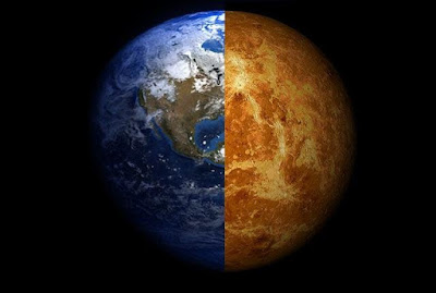
Minor evolutionary changes could have altered the fates of both Earth and Venus. Credit: Composite image by Arie Wilson Passwaters/Rice University
Minor evolutionary changes could have altered the fates of both Earth and Venus.
Credit: Composite image by Arie Wilson Passwaters/Rice University
If conditions had been just a little different an eon ago, there might be plentiful life on Venus and none on Earth.

The idea isn't so far-fetched, according to a hypothesis by Rice University scientists and their colleagues who published their thoughts on life-sustaining planets, the planets' histories and the possibility of finding more in Astrobiology this month.

The researchers maintain that minor evolutionary changes could have altered the fates of both Earth and Venus in ways that scientists may soon be able to model through observation of other solar systems, particularly ones in the process of forming, according to Rice Earth scientist Adrian Lenardic.

The paper, he said, includes "a little bit about the philosophy of science as well as the science itself, and about how we might search in the future. It's a bit of a different spin because we haven't actually ­­­­done the work, in terms of searching for signs of life outside our solar system, yet. It's about how we go about doing the work."

Lenardic and his colleagues suggested that habitable planets may lie outside the "Goldilocks zone" in extra-solar systems, and that planets farther from or closer to their suns than Earth may harbor the conditions necessary for life.

The Goldilocks zone has long been defined as the band of space around a star that is not too warm, not too cold, rocky and with the right conditions for maintaining surface water and a breathable atmosphere. But that description, which to date scientists have only been able to calibrate using observations from our own solar system, may be too limiting, Lenardic said.

"For a long time we've been living, effectively, in one experiment, our solar system," he said, channeling his mentor, the late William Kaula. Kaula is considered the father of space geodetics, a system by which all the properties in a planetary system can be quantified. "Although the paper is about planets, in one way it's about old issues that scientists have: the balance between chance and necessity, laws and contingencies, strict determinism and probability.

"But in another way, it asks whether, if you could run the experiment again, would it turn out like this solar system or not? For a long time, it was a purely philosophical question. Now that we're observing solar systems and other planets around other stars, we can ask that as a scientific question.

"If we find a planet (in another solar system) sitting where Venus is that actually has signs of life, we'll know that what we see in our solar system is not universal," he said.

In expanding the notion of habitable zones, the researchers determined that life on Earth itself isn't necessarily a given based on the Goldilocks concept. A nudge this way or that in the conditions that existed early in the planet's formation may have made it inhospitable.

By extension, a similarly small variation could have changed the fortunes of Venus, Earth's closest neighbor, preventing it from becoming a burning desert with an atmosphere poisonous to terrestrials.

The paper also questions the idea that plate tectonics is a critical reason Earth harbors life. "There's debate about this, but the Earth in its earliest lifetimes, let's say 2-3 billion years ago, would have looked for all intents and purposes like an alien planet," Lenardic said. "We know the atmosphere was completely different, with no oxygen. There's a debate that plate tectonics might not have been operative.

"Yet there's no argument there was life then, even in this different a setting. The Earth itself could have transitioned between planetary states as it evolved. So we have to ask ourselves as we look at other planets, should we rule out an early Earth-like situation even if there's no sign of oxygen and potentially a tectonic mode distinctly different from the one that operates on our planet at present?

"Habitability is an evolutionary variable," he said. "Understanding how life and a planet co-evolve is something we need to think about."

Lenardic is kicking his ideas into action, spending time this summer at conferences with the engineers designing future space telescopes. The right instruments will greatly enhance the ability to find, characterize and build a database of distant solar systems and their planets, and perhaps even find signs of life.

"There are things that are on the horizon that, when I was a student, it was crazy to even think about," he said. "Our paper is in many ways about imagining, within the laws of physics, chemistry and biology, how things could be over a range of planets, not just the ones we currently have access to. Given that we will have access to more observations, it seems to me we should not limit our imagination as it leads to alternate hypothesis."

###

Rice graduate student Matt Weller, now a postdoctoral fellow at the Lunar and Planetary Institute, is a co-author of the paper. Additional co-authors are John Crowley, a geodetic engineer at the Canadian Geodetic Survey of Natural Resources Canada and an adjunct professor in the Department of Earth and Environmental Sciences at the University of Ottawa, and Mark Jellinek, a professor of volcanology, geodynamics, planetary science and geological fluid mechanics at the University of British Columbia.

The National Science Foundation supported the research.
Follow Rice News and Media Relations via Twitter @RiceUNews.

Related materials:
Rice Department of Earth Science: http://earthscience.rice.edu

Located on a 300-acre forested campus in Houston, Rice University is consistently ranked among the nation's top 20 universities by U.S. News & World Report. Rice has highly respected schools of Architecture, Business, Continuing Studies, Engineering, Humanities, Music, Natural Sciences and Social Sciences and is home to the Baker Institute for Public Policy. With 3,910 undergraduates and 2,809 graduate students, Rice's undergraduate student-to-faculty ratio is 6-to-1. Its residential college system builds close-knit communities and lifelong friendships, just one reason why Rice is ranked No. 1 for best quality of life and for lots of race/class interaction by the Princeton Review. Rice is also rated as a best value among private universities by Kiplinger's Personal Finance. To read "What they're saying about Rice," go to http://tinyurl.com/RiceUniversityoverview.
***

Source:
The above post is reprinted from materials provided by Rice University.
The latest Research, Reviews, News and information about Geology / Earth Science from around the web. GEOLOGY INFO
Cutaway of the Earth's surface, down to the liquid core. A numerical convection experiment shows blobs in green, surrounding mantle rock in blue, and former oceanic crust from the surface that has subducted into the interior in yellow. Credit: Dr. Mingming Li/University of Colorado
Two massive blob-like structures lie deep within Earth, roughly on opposite sides of the planet. The two structures, each the size of a continent and 100 times taller than Mount Everest, sit on the core, 1,800 miles deep, and about halfway to the center of Earth.

Arizona State University scientists Edward Garnero, Allen McNamara and Sang-Heon (Dan) Shim, of the School of Earth and Space Exploration, suggest these blobs are made of something different from the rest of Earth's mantle. The scientists' work appears in the June issue of Nature Geoscience.

"While the origin and composition of the blobs are yet unknown," said Garnero, "we suspect they hold important clues as to how Earth was formed and how it works today."

The blobs, he says, may also help explain the plumbing that leads to some massive volcanic eruptions, as well as the mechanism of plate tectonics from the convection, or stirring, of the mantle. This is the geo-force that drives earthquakes.

Deep stirring

Earth is layered like an onion, with a thin outer crust, a thick viscous mantle, a fluid outer core and a solid inner core. The two blobs sit in the mantle on top of Earth's core, under the Pacific Ocean on one side and beneath Africa and the Atlantic Ocean on the other.

Waves from earthquakes passing through Earth's deep interior have revealed that these blobs are regions where seismic waves travel slowly. The mantle materials that surround these regions are thought to be composed of cooler rocks, associated with the downward movement of tectonic plates.

The blobs, also called thermochemical piles, have long been depicted as warmer-than-average mantle materials, pushed upward by a slow churning of hot mantle rock. The new paper argues they are also chemically different from the surrounding mantle rock, and may partly contain material pushed down by plate tectonics. They might even be material left over from Earth's formation, 4.5 billion years ago.

Much is yet to be learned about these blobs. But the emerging view from seismic and geodynamic information is that they appear denser than the surrounding mantle materials, are dynamically stable and long-lived, and have been shaped by the mantle's large-scale flow. The scientists expect that further work on the two deep-seated anomalies will help clarify the picture and tell of their origin.

"If a neuroscientist found an unknown structure in the human brain, the whole community of brain scientists, from psychologists to surgeons, would actively pursue understanding its role in the function of the whole system," Garnero said.

"As the thermochemical piles come into sharper focus, we hope other Earth scientists will explore how these features fit into the big puzzle of planet Earth."

Source:
The above post is reprinted from materials provided by Arizona State University (ASU).

Reference:
Edward J. Garnero, Allen K. McNamara, Sang-Heon Shim. Continent-sized anomalous zones with low seismic velocity at the base of Earth's mantle. Nature Geoscience, 2016; DOI: 10.1038/NGEO2733
The latest Research, Reviews, News and information about Geology / Earth Science from around the web. GEOLOGY INFO
This is an illustration of ancient Earth's magnetic field compared to the modern magnetic field courtesy of Peter Driscoll. Credit: Peter Driscoll
New work from Carnegie's Peter Driscoll suggests Earth's ancient magnetic field was significantly different than the present day field, originating from several poles rather than the familiar two. It is published in Geophysical Research Letters.

Earth generates a strong magnetic field extending from the core out into space that shields the atmosphere and deflects harmful high-energy particles from the Sun and the cosmos. Without it, our planet would be bombarded by cosmic radiation, and life on Earth's surface might not exist. The motion of liquid iron in Earth's outer core drives a phenomenon called the geodynamo, which creates Earth's magnetic field. This motion is driven by the loss of heat from the core and the solidification of the inner core.

But the planet's inner core was not always solid. What effect did the initial solidification of the inner core have on the magnetic field? Figuring out when it happened and how the field responded has created a particularly vexing and elusive problem for those trying to understand our planet's geologic evolution, a problem that Driscoll set out to resolve.

Here's the issue: Scientists are able to reconstruct the planet's magnetic record through analysis of ancient rocks that still bear a signature of the magnetic polarity of the era in which they were formed. This record suggests that the field has been active and dipolar--having two poles--through much of our planet's history. The geological record also doesn't show much evidence for major changes in the intensity of the ancient magnetic field over the past 4 billion years. A critical exception is in the Neoproterozoic Era, 0.5 to 1 billion years ago, where gaps in the intensity record and anomalous directions exist. Could this exception be explained by a major event like the solidification of the planet's inner core?

In order to address this question, Driscoll modeled the planet's thermal history going back 4.5 billion years. His models indicate that the inner core should have begun to solidify around 650 million years ago. Using further 3-D dynamo simulations, which model the generation of magnetic field by turbulent fluid motions, Driscoll looked more carefully at the expected changes in the magnetic field over this period.

"What I found was a surprising amount of variability," Driscoll said. "These new models do not support the assumption of a stable dipole field at all times, contrary to what we'd previously believed."

His results showed that around 1 billion years ago, Earth could have transitioned from a modern-looking field, having a "strong" magnetic field with two opposite poles in the north and south of the planet, to having a "weak" magnetic field that fluctuated wildly in terms of intensity and direction and originated from several poles. Then, shortly after the predicted timing of the core solidification event, Driscoll's dynamo simulations predict that Earth's magnetic field transitioned back to a "strong," two-pole one.

"These findings could offer an explanation for the bizarre fluctuations in magnetic field direction seen in the geologic record around 600 to 700 million years ago," Driscoll added. "And there are widespread implications for such dramatic field changes."

Overall, the findings have major implications for Earth's thermal and magnetic history, particularly when it comes to how magnetic measurements are used to reconstruct continental motions and ancient climates. Driscoll's modeling and simulations will have to be compared with future data gleaned from high quality magnetized rocks to assess the viability of the new hypothesis.
***

Source:
The above post is reprinted from materials provided by Carnegie Institution for Science.

Reference:
Peter E. Driscoll. Simulating Two Billion Years of Geodynamo History. Geophysical Research Letters, 2016; DOI: 10.1002/2016GL068858

The latest Research, Reviews, News and information about Geology / Earth Science from around the web. GEOLOGY INFO
An LEM showing coastal response to a dome of dynamic uplift, as it moves across the landscape from left to right at two centimeters a year. The dome is centered in Panel C, in the lower lefthand corner. Credit: Image courtesy of Syracuse University
Robert Moucha, assistant professor of geophysics, and Gregory Ruetenik, a Ph.D. student in Earth sciences, have collaborated with Gregory Hoke, associate professor of Earth sciences, on a unique numerical modeling study that simulates changing terrain over millions of years. Their study shows that moderate changes in dynamic topography produce an erosional response in the form of increased sediment flux to continental margins (i.e., the rate of sediments supplied to margins by streams and rivers).

Their findings are the subject of an article in Terra Nova (Wiley Online Library, 2016), and have major implications for the study of geomorphology, geodynamics and climate.

"This kind of modeling contributes to our understanding of mantle convection," says Moucha, referring to the process in which heat from inside Earth rises to the surface. "By drawing on elements of physics, chemistry and mathematics, we can infer how Earth's surface evolution is affected by mantle convection and the interaction with various crust and surface processes, including the climate."

Erosional response usually persists long after dynamic topography, and is dependent on the interplay of uplift rate, rock and soil erosion and initial topography.

Dynamic topography is the resulting surface deformation, characterized by long, low-amplitude, wave-length undulations, driven by convection in Earth's mantle.

Because changes in dynamic topography occur over millions of years, geophysicists often rely on backward-in-time models to estimate global mantle flow and changes in dynamic topography. Evaluating these models, however, can be problematic.

"Comparing backward-in-time models of dynamic topography with observed offshore sedimentary records is challenging," Moucha says. "The problem with this approach is that it's difficult to deconvolve the observed record into contributions from changes in climate, tectonics and dynamic topography. As a result, we get disparities in our comparisons."

To rectify the situation, Ruetenik and Moucha have constructed a landscape evolution model (LEM) that quantifies landscape responses to moderate changes in dynamic topography.

LEMs are nothing new -- geophysicists have been using the grid-like programs since the '90s to simulate fluvial and slope erosion -- but Ruetenik and Moucha have taken enhanced computing to a new level. Their LEM uses advanced mathematical modeling to show how processes such as climate, erosion and uplift influence the formation of river systems and drainage areas over large continental scales and tens of millions years.

This is in contrast to traditional LEMs, which are designed for regional studies and periods between 10,000-100,000 years, and, thus, are unable to capture large-scale changes in dynamic topography.

"Our focus here was to characterize the erosional response to changes in dynamic topography, in terms of the sedimentary flux to continental margins," Moucha says. "We also considered the effects of offshore sediment deposition and changes in precipitation."

A versatile scientist in large-scale geophysics and geodynamics, Moucha is interested in the topography of Africa, Norway and the southwestern United States and in long-term sea-level change along the eastern coast of North America.

His new LEM utilizes a hypothetical continental that moves from east to west, across a 200-meter-high, 200-kilometer-wide dynamic topography dome. The purpose of the dome, he says, is to record erosion and sedimentation, as well as drainage basin evolution.

"We've found that moderate changes in dynamic topography modulated the erosional response of landscapes with pre-existing relief," Moucha says. "This results in enhanced sediment flux that can persist for tens of millions of years, as the landscape re-equilibrates. The response is maximized when moderate changes [in dynamic topography] are long-lived and erodibility is high."

He and Ruetenik also have found that the stream and river network is dependent on the direction of the wave of uplift sweeping across the landscape.

"Upstream propagation is more likely to reroute streams, whereas streams maintain their course when propagation is downstream," Moucha says. "This kind of research provides a roadmap for understanding the tectonic evolution of our planet. It also creates a framework for integrating independent geophysical techniques with geological observations."
***

Source:
The above post is reprinted from materials provided by Syracuse University. The original item was written by Rob Enslin.

Reference:
Gregory A. Ruetenik, Robert Moucha, Gregory D. Hoke. Landscape Response to Changes in Dynamic Topography. Terra Nova, 2016; DOI: 10.1111/ter.12220
The latest Research, Reviews, News and information about Geology / Earth Science from around the web. GEOLOGY INFO
An artwork depicting the decomposition of FeOOH in lower mantle conditions. The cycle starts from ?-FeOOH (blue dot on the top) to its high-pressure form (brown dot), to FeO2 (center crystal) and hydrogen (cyan bubbles), and finally produce other minerals (bubbles on the left side).
Credit: Courtesy of Ms. Xiaoya.
Using laboratory techniques to mimic the conditions found deep inside Earth, a team of Carnegie scientists led by Ho-Kwang "Dave" Mao has identified a form of iron oxide that they believe could explain seismic and geothermal signatures in the deep mantle. Their work is published in Nature.

Iron and oxygen are two of the most geochemically important elements on Earth. The core is rich in iron and the atmosphere is rich in oxygen, and between them is the entire range of pressures and temperatures on the planet.

"Interactions between oxygen and iron dictate Earth's formation, differentiation--or the separation of the core and mantle--and the evolution of our atmosphere, so naturally we were curious to probe how such reactions would change under the high-pressure conditions of the deep Earth," said Mao.

The research team--Qingyang Hu, Duck Young Kim, Wenge Yang, Liuxiang Yang, Yue Meng, Li Zhang, & Ho-Kwang Mao--put ordinary rust, or FeOOH, under about 900,000 times normal atmospheric pressure and at about 3200 degrees Fahrenheit and were able to synthesize a form of iron oxide, FeO2, that structurally resembles pyrite, also known as fool's gold. The reaction gave off hydrogen in the form of H2.

FeOOH is found in iron ore deposits that exist in bogs, so it could easily move into the deep Earth at plate tectonic boundaries, as could samples of ferric oxide, Fe2O3, which along with water will also form the pyrite-like iron oxide under deep lower mantle conditions.

Why does this interest the researchers? For one thing, this type of reaction could have started in Earth's infancy, and understanding it could inform theories of our own planet's evolution, as well as its current geochemistry.

Furthermore, the H2 released in this reaction would work its way upward, possibly reacting with other materials on its way. Meanwhile, the iron oxide would settle planet's depths and form reservoirs of oxygen there, particularly if one of these patches of iron oxide moved upward along the pressure gradient to the middle part of the mantle and separated into iron and O2.

"Pools of free oxygen under these conditions could create many reactions and chemical phases, which might be responsible for seismic and geochemical signatures of the deep Earth," Mao explained.

"Our experiments mimicking mantle conditions demonstrate that more research is needed on this pyrite-like phase of iron oxide." Hu added.

The research team believes their findings could even offer an alternate explanation for the Great Oxygenation Event that changed Earth's atmosphere between 2 and 2.5 billion years ago. The rise of bacteria performing photosynthesis, which releases oxygen as a byproduct, is often considered the source of the rapid increase in atmospheric oxygen, which had previously been scarce. But releases of oxygen from upwelling of deep mantle FeO2 patches could provide an abiotic explanation for the phenomenon, they say.
***

Source:
The above post is reprinted from materials provided by Carnegie Institution for Science.

Reference:
Qingyang Hu, Duck Young Kim, Wenge Yang, Liuxiang Yang, Yue Meng, Li Zhang, Ho-Kwang Mao. FeO2 and FeOOH under deep lower-mantle conditions and Earth’s oxygen–hydrogen cycles. Nature, 2016; 534 (7606): 241 DOI: 10.1038/nature18018
The latest Research, Reviews, News and information about Geology / Earth Science from around the web. GEOLOGY INFO
This is an illustration of how the diamond anvil cell is used to mimic and study planetary core conditions.
Credit: Stewart McWilliams
Earth's magnetic field shields us from deadly cosmic radiation, and without it, life as we know it could not exist here. The motion of liquid iron in the planet's outer core, a phenomenon called a "geodynamo," generates the field. But how it was first created and then sustained throughout Earth's history has remained a mystery to scientists. New work published in Nature from a team led by Carnegie's Alexander Goncharov sheds light on the history of this incredibly important geologic occurrence.

Our planet accreted from rocky material that surrounded our Sun in its youth, and over time the most-dense stuff, iron, sank inward, creating the layers that we know exist today--core, mantle, and crust. Currently, the inner core is solid iron, with some other materials that were dragged along down during this layering process. The outer core is a liquid iron alloy, and its motion gives rise to the magnetic field.

A better understanding of how heat is conducted by the solid of the inner core and the liquid in the outer core is needed to piece together the processes by which our planet, and our magnetic field, evolved--and, even more importantly, the energy that sustains a continuous magnetic field. But these materials obviously exist under very extreme conditions, both very high temperatures and very intense pressures. This means that their behavior isn't going to be the same as it is on the surface.

"We sensed a pressing need for direct thermal conductivity measurements of core materials under conditions relevant to the core," Goncharov said. "Because, of course, it is impossible for us to reach anywhere close to Earth's core and take samples for ourselves."

The team used a tool called a laser-heated diamond anvil cell to mimic planetary core conditions and study how iron conducts heat under them. The diamond anvil cell squeezes tiny samples of material in between two diamonds, creating the extreme pressures of the deep Earth in the lab. The laser heats the materials to the necessary core temperatures.

Using this kind of lab-based mimicry, the team was able to look at samples of iron across temperatures and pressures that would be found inside planets ranging in size from Mercury to Earth--345,000 to 1.3 million times normal atmospheric pressure and 2,400 to 4,900 degrees Fahrenheit--and study how they propagate heat.

They found that the ability of these iron samples to transmit heat matched with the lower end of previous estimates of thermal conductivity in Earth's core--between 18 and 44 watts per meter per kelvin, in the units scientists use to measure such things. This translates to predictions that the energy necessary to sustain the geodynamo has been available since very early in the history of Earth.

"In order to better understand core heat conductivity, we will next need to tackle how the non-iron materials that went along for the ride when iron sunk to the core affect these thermal processes inside of our planet," Goncharov added.
***

Story Source:
The above post is reprinted from materials provided by Carnegie Institution for Science.

Journal Reference:
Zuzana Konôpková, R. Stewart McWilliams, Natalia Gómez-Pérez, Alexander F. Goncharov. Direct measurement of thermal conductivity in solid iron at planetary core conditions. Nature, 2016; 534 (7605): 99 DOI: 10.1038/nature18009