Articles by "Volcanology"
Showing posts with label Volcanology. Show all posts
The latest Research, Reviews, News and information about Geology / Earth Science from around the web. GEOLOGY INFO
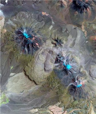
The Chao volcano in northern Chile with a lava coulée approx. 14.5 km long (centre of picture). The composition of the lava matches that of deposits of adjacent supervolcanic calderas. Chao erupted about 75,000 years ago, but zircon crystals in the lava were already forming in a subterranean magma reservoir for nearly three million years. Credit: Landsat 8, U.S. Geological Survey
Geoscientists from Heidelberg University have discovered accumulations of magma in the Andes sufficient to have set off a super-eruption but which, in fact, did not. Such eruptions, which expel enormous quantities of magma, are the largest volcanic events on earth. Together with colleagues from the USA, researchers from the Institute of Earth Sciences discovered that magma volumes of supervolcanic proportions have been continuously accumulating in the Altiplano-Puna region since the last super-eruption nearly 2.9 million years ago. These magmas, however, did not reach the surface to trigger a catastrophic eruption but instead slowly cooled at depth and hardened into plutonic rock. The results of the research were published in the journal Geology.

"A supervolcanic eruption spews out more than 1,000 cubic kilometres of magma, which accumulated over time in reservoirs close the earth's surface," explains Prof. Dr Axel Schmitt of the Institute of Earth Sciences. "In turn, these reservoirs are fed from deeper layers in the earth's crust and the underlying mantle. During an eruption, the overlying rock layers collapse into the empty magma chamber and form depressions, known as calderas, of up to 100 kilometres in diameter." Axel Schmitt indicates that there have been at least seven super-eruptions in the Altiplano-Puna region within the last ten million years, the most recent one about 2.9 million years ago. What remains unclear is why no further major eruptions have occurred since then and whether the region can now be considered inactive for such events.

Using samples from five comparatively small lava domes in northern Chile and southeast Bolivia, the Heidelberg researchers and their American colleagues investigated the most recent eruptions whose chemical composition matches the supervolcanic magmas from the region. They determined the age of very small zircon crystals from these lava flows with the aid of a high-spatial-resolution mass spectrometer. "The mineral zircon forms almost exclusively in magmas, so its age revealss when those magmas were present under the volcano," explains Axel Schmitt. "The astonishing result was that the ages of the zircons measured from all five of the smaller volcanoes extended continuously from the time of the eruption 75,000 years ago back to the last supervolcanic eruption."

Prof. Schmitt reports that model calculations demonstrated that zircon formation is only possible over such protracted durations if the inflow of magma amounted to approx. one cubic kilometre over 1,000 years, which is unusually high for a relatively small volcano. "This means that over a long period of time a magma volume of supervolcanic proportions must have accumulated under the five lava domes, which then solidified into plutonic rock at depth." The volcanologist explains that the lack of a major volcanic eruption does not necessarily indicate that magmatic activity has come to a complete halt. Perhaps the rise in magma from deeper regions merely slowed during the last 2.9 million years, forming an enormous body of rock known as a pluton.

"However, our results also show that a relatively small increase in the long-term magma recharge from about one to five cubic kilometres in 1,000 years would recreate conditions favouring a catastrophic supervolcanic eruption. A new super-eruption in the Altiplano-Puna region would be possible, but only after a long lead time," explains Prof. Schmitt.

Researchers from Oregon State University and the University of California in Los Angeles also contributed to the research.
***
Source:
The above post is reprinted from materials provided by Heidelberg University.

Reference:
Casey R. Tierney, Axel K. Schmitt, Oscar M. Lovera, Shanaka L. de Silva. Voluminous plutonism during volcanic quiescence revealed by thermochemical modeling of zircon. Geology, 2016; 44 (8): 683 DOI: 10.1130/G37968.1
The latest Research, Reviews, News and information about Geology / Earth Science from around the web. GEOLOGY INFO
Ilopango lake and San Vicente volcano, Salvador. Credit: Carlos Rodriguez Mata // flickr
Ilopango lake and San Vicente volcano, Salvador.
Credit: Carlos Rodriguez Mata // flickr
The build-up of magma six kilometres below El Salvador's Ilopango caldera means the capital city of San Salvador may be at risk from future eruptions, University of Bristol researchers have found.

A caldera is a large cauldron-like volcanic depression or crater, formed by the collapse of an emptied magma chamber. The depression often originates from very big explosive eruptions. In Guatemala and El Salvador, caldera volcanoes straddle tectonic fault zones along the Central American Volcanic Arc (CAVA). The CAVA is 1,500 kilometres long, stretching from Guatemala to Panama.

The team, from the Volcanology research group at Bristol's School of Earth Sciences and the Ministry of the Environment and Natural Resources in El Salvador, studied the density distribution beneath the Ilopango caldera and the role tectonic stresses -- caused by the movement of tectonic plates along fault lines -- have on the build-up of magma at depth. Their study is published in the journal Nature Communications.

The Ilopango caldera is an eight km by 11 kilometre volcanic collapse structure of the El Salvador Fault Zone. The collapsed caldera was the result of at least five large eruptions over the past 80,000 years.

The last of these occurred about 1,500 years ago and produced enough volcanic ash to form a 15 centimetre thick layer across the entire UK. This catastrophic eruption destroyed practically everything within a 100 kilometre radius, including a well-developed native Mayan population, and significantly disturbed the Mayan populations as far as 200 kilometres away.

The most recent eruptions occurred in 1879-1880 and were on a much smaller scale than the previous one.

Project leader and co-author Dr Joachim Gottsmann said: "Most earthquakes take place along the edges of tectonic plates, where many volcanoes are also located. There is therefore a link between the breaking of rocks, which causes faults and earthquakes and the movement of magma from depth to the surface, to feed a volcanic eruption. The link between large tectonic fault zones and volcanism is, however, not very well understood."

Existing studies show that magma accumulation before a large caldera-forming eruption, as well as the caldera collapse itself, may be controlled by fault structures.

"However, it is unclear to what extent regional tectonic stresses influence magma accumulation between large caldera-forming eruptions.," co-author Professor Katharine Cashman said.

Lead author Jennifer Saxby, whose research towards a MSc in Volcanology contributed to the study, said: "Addressing this question is important not only for understanding controls on the development of magmatic systems, but also for forecasting probable locations of future eruptive activity from caldera-forming volcanoes."

The team discovered that the current tectonic stress field promotes the accumulation of magma and hydrothermal fluids at shallow (< 6km) depth beneath Ilopango. The magma contains a considerable amount of gas, which indicates the system is charged to possibly feed the next eruption.

Dr Gottsmann said: "Our results indicate that localised extension along the fault zone controls the accumulation, ascent and eruption of magma at Ilopango. This fault-controlled magma accumulation and movement limits potential vent locations for future eruptions at the caldera in its central, western and northern part -- an area that now forms part of the metropolitan area of San Salvador, which is home to 2 million people. As a consequence, there is a significant level of risk to San Salvador from future eruptions of Ilopango."
***

Source:
The above post is reprinted from materials provided by University of Bristol.

Reference:
J. Saxby, J. Gottsmann, K. Cashman, E. Gutiérrez. Magma storage in a strike-slip caldera. Nature Communications, 2016; 7: 12295 DOI: 10.1038/ncomms12295
The latest Research, Reviews, News and information about Geology / Earth Science from around the web. GEOLOGY INFO
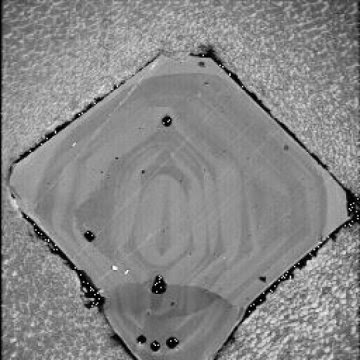
One of the 73 quartz crystals used in the study. They averaged about one millimeter in diameter. Credit: Guilherme Gualda, Vanderbilt University
Super-eruptions - volcanic events large enough to devastate the entire planet - give only about a year's warning before they blow.

That is the conclusion of a new microscopic analysis of quartz crystals in pumice taken from the Bishop Tuff in eastern California, which is the site of the super-eruption that formed the Long Valley Caldera 760,000 years ago.

The study is described in the paper "The year leading to a supereruption" by Guilherme Gualda, associate professor of earth and environment sciences at Vanderbilt University, and Stephen Sutton at the University of Chicago published July 20 in the journal PLOS One.

"The evolution of a giant, super-eruption-feeding magma body is characterized by events taking place at a variety of time scales," said Gualda. Tens of thousands of years are needed to prime the crust to generate sufficient eruptible magma. Once established, these melt-rich, giant magma bodies are unstable features that last for only centuries to few millennia. "Now we have shown that the onset of the process of decompression, which releases the gas bubbles that power the eruption, starts less than a year before eruption."

Gualda and Sutton analyzed dozens of small quartz crystals from the Bishop Tuff. Previous investigations of quartz crystals from several super-eruptions, including Long Valley, have noted that they have distinctive surface rims. These studies concluded that the rims formed in less than a century before eruption.

The new study uses a more accurate method for measuring rim growth times pinned on variations in the concentration of titanium in the crystal. Titanium is one of the few impurities that is incorporated into quartz in appreciable amounts and it diffuses fast enough to permit probing of time scales as short as minutes. However, it is extremely difficult to measure the small levels of titanium involved at sufficient spatial resolution. So the researchers established that the concentration of titanium in quartz directly correlates with the amount of light produced when a material is bombarded by electrons, an effect called cathodoluminescence. This allowed them to use cathodoluminescence images to make high-resolution measurements of variations in titanium concentration and, based on this, to determine rim growth times and growth rates.

"Maximum rim growth times span from approximately 1 minute to 35 years, with a median of approximately 4 days. More than 70 percent of rim growth times are less than 1 year, showing that quartz rims have mostly grown in the days to months prior to eruption... . Growth took place under conditions of high supersaturation suggesting that rim growth marks the onset of decompression and the transition from pre-eruptive to syn-eruptive conditions," the paper summarized.

According to Gualda, the decompression period would likely be accompanied by the expansion of the magma body which should have detectable effects on the Earth's surface. While more work is needed to understand what exactly the signs at the surface would be, the study suggests that signs of an impending super-eruption would start to be felt within a year of eruption, and they would intensify as the eruption neared.

Very large eruptions -- including super-eruptions -- have taken place in a number of places worldwide in the recent geological past. The Taupo Volcanic Zone in New Zealand was the site of the most recent super-eruption -- the Oruanui eruption at 26,500 years -- and it includes deposits from more than a dozen very large eruptions that took place in the last couple of million years. Campi Flegrei in Italy produced a very large eruption 40,000 years ago. Indonesia was the site of the Toba super-eruption in Sumatra 75,000 years ago and the Tambora eruption in 1815. In the United States, Yellowstone has experienced three super-eruptions over the last two million years. In light of this evidence, it seems inevitable that another super-eruption will strike the Earth in the future.

"As far as we can determine, none of these places currently house the type of melt-rich, giant magma body needed to produce a super-eruption," said Gualda. "However, they are places where super-eruptions have happened in the past so are more likely to happen in the future."

Gualda and Sutton's study provides new insights into the timescales over which the initiation of such a potentially civilization-ending event would take place.
***

Source:
The above post is reprinted from materials provided by Vanderbilt University. The original item was written by David F Salisbury.

Reference:
Guilherme A. R. Gualda, Stephen R. Sutton. The Year Leading to a Supereruption. PLOS ONE, 2016; 11 (7): e0159200 DOI: 10.1371/journal.pone.0159200
The latest Research, Reviews, News and information about Geology / Earth Science from around the web. GEOLOGY INFO
The Bardarbunga eruption on Iceland has broken many records. The event in 2014 was the strongest in Europe since more than 240 years. The hole it left behind, the so-called caldera, is the biggest caldera formation ever observed. And the event as such was studied in unprecedented detail by a team of international scientists, amongst them a group from the GFZ German Research Centre for Geosciences. Credit: GFZ German Research Centre for Geosciences
The Bárdarbunga eruption on Iceland has broken many records. The event in 2014 was the strongest in Europe since more than 240 years. The hole it left behind, the so-called caldera, is the biggest caldera formation ever observed. And the event as such was studied in unprecedented detail by a team of international scientists, amongst them a group from the GFZ German Research Centre for Geosciences. Together with lead author Magnus T. Gudmundsson from the University of Iceland, the team has now published its findings in the upcoming issue of Science.

From August 2014 to February 2015, the Bárdabunga caldera was formed in the centre of Iceland. Calderas are kettle-shaped volcanic structures with a diameter of one kilometer up to 100 kilometers. They form through the collapse of subterranean magma reservoirs during volcanic eruptions. Since their formation is not very frequent, knowledge of such calderas is scarce. As part of an international team, GFZ scientists from the section Physics of Earthquakes and Volcanoes documented the event in great detail. The scientists used satellite images, seismological and geochemical data, GPS data and modelling.

The process of subsidence was triggered by the lateral intrusion of magma from a reservoir 12 kilometers below the surface. The magma flowed for 45 kilometers along a subterranean path before erupting as a major lava flow northeast of the volcano. The subsidence was accompanied by 77 earthquakes reaching magnitudes larger than M 5.

In their study, the scientists show how the ice-filled subsidence bowl developed gradually over the course of six months to become eight by eleven kilometers wide and up to 65 meters deep. "With an area of 110 square kilometers, this is the largest caldera collapse ever monitored. The results provide the clearest picture yet of the onset and evolution of this enigmatic geological process," says Dr. Eoghan Holohan, who led the modelling part of this work at the GFZ.

Dr. Sebastian Heimann (GFZ) investigated the mechanisms underlying the collapse using seismological methods. "The typical structure of seismic waves in volcanic eruptions can be used to infer the type of deformation directly above the magmatic chamber." The result of his analysis indicates that steeply-dipping ring faults controlled the subsidence at depth.

Another surprise for the scientists was how the magma behaved within the canal beneath the surface. "Interestingly, the eruption site and the magma chamber were coupled hydraulically over 45 kilometers," says Dr. Thomas Walter from the GFZ. He compares the effect to a hose pipe level. Tremors and seismic shocks at the eruption site propagated to the magma chamber at the other end and vice versa.

The chamber lies beneath Europe's largest glacier, the Vatnajökull, and the caldera was filled with ice. Thomas Walter says: "The event was a blessing in disguise as the eruption could have happened directly beneath the ice. In that case, we'd have had a water vapour explosion with a volcanic ash cloud even bigger and longer lasting than the one that followed the eruption of Eyjafjallajökull in 2010." For comparison: The Bárdabunga eruption blew out two cubic kilometers of volcanic material over the course of several months, nearly ten times more than the Eyjafjallajökull.

With the data they gathered, the geoscientists hope to gain deeper insights into the currently un-explored mechanisms of caldera formation. Eruptions connected to such processes can be far bigger than the observed Icelandic event. Catastrophic events can occur for instance at Yellowstone, USA, or in the Andes region. Exactly 200 years ago, the eruption of the Tambora volcano in Indonesia and the subsequent caldera formation lead to an atmospheric shock wave that could be measured globally as well as to a devastating tsunami. The volcanic aerosols and ash in the stratosphere brought the infamous "year without summer" in 1816.
***

Source:
The above post is reprinted from materials provided by GFZ GeoForschungsZentrum Potsdam, Helmholtz Centre.

Reference:
M. T. Gudmundsson, K. Jonsdottir, A. Hooper, E. P. Holohan, S. A. Halldorsson, B. G. Ofeigsson, S. Cesca, K. S. Vogfjord, F. Sigmundsson, T. Hognadottir, P. Einarsson, O. Sigmarsson, A. H. Jarosch, K. Jonasson, E. Magnusson, S. Hreinsdottir, M. Bagnardi, M. M. Parks, V. Hjorleifsdottir, F. Palsson, T. R. Walter, M. P. J. Schopfer, S. Heimann, H. I. Reynolds, S. Dumont, E. Bali, G. H. Gudfinnsson, T. Dahm, M. J. Roberts, M. Hensch, J. M. C. Belart, K. Spaans, S. Jakobsson, G. B. Gudmundsson, H. M. Fridriksdottir, V. Drouin, T. Durig, G. Athalgeirsdottir, M. S. Riishuus, G. B. M. Pedersen, T. van Boeckel, B. Oddsson, M. A. Pfeffer, S. Barsotti, B. Bergsson, A. Donovan, M. R. Burton, A. Aiuppa. Gradual caldera collapse at Bardarbunga volcano, Iceland, regulated by lateral magma outflow. Science, 2016; 353 (6296): aaf8988 DOI: 10.1126/science.aaf8988
The latest Research, Reviews, News and information about Geology / Earth Science from around the web. GEOLOGY INFO
City of Naples with Mount Vesuvius at sunset.
Credit: Antonsusi
New work by Italian geochemists seems to indicate that the current ground movement around one of the world's most dangerous volcano systems may be due to gas pressure, and not because of a surge of volcanic magma. This work was recently presented at the Goldschmidt conference in Yokohama, Japan (30 June 2016).

The Campi Flegrei (Phlegraean Fields), just across the Bay of Naples from the famous Vesuvius volcano, is amongst the most dangerous volcanos on Earth. In the past it has been capable of a "VEI 7" eruption (Volcanic Explosivity Index of 7, meaning that it has produced an explosive eruption even bigger than the famous Krakatoa eruption of 1883). However, this was around 40,000 years ago. The last eruption, "VEI 2" occurred in 1538 AD.

Because of the geological instability in the area, the land in this area can rise and fall by several metres over just a few years, a phenomenon known as Bradyseism. The last few years have seen the ground in the area begin to rise again, with a 38 cm rise recorded since late 2005. There have been worries that this may presage an eruption.

The last serious geological unrest in the area was in 1982-84, which saw ground levels rise by up to 1.8m. Most scientists think that the movement in this period was caused by mixed magmatic- hydrothermal activity (although some recent papers in the geochemical literature have suggested a major role for hydrothermal processes supported by deep magmatic gases, with pressurised water causing the land to rise). On the other hand, consensus exists that the current activity is caused by molten magma movement and accumulation under the Campi -- which carries a greater risk of an eruption. Now however, a group of Geochemists from Second University of Naples and the Vesuvius Observatory think that the consensus has got it exactly the wrong way round.

Lead researcher, Professor Roberto Moretti (Seconda Università degli Studi di Napoli) commented: "Everyone accepts the geochemical evidence that current activity has different causes to that of 1982-84. Most geochemists are now showing that the 1982-84 movement was caused by hydrothermal activity and the current activity is caused by magma, but we think that it's exactly the other way round. We have checked geochemical records going back over more than 30 years, and our ongoing interpretation -- looking at released gases and physical signals -- seem to be consistent with current activity being hydrothermal, with the support of deep magmatic gases, rather than due to magma migration or growth of a shallow (3-4 km deep) magma chamber. We believe that this magma dynamics characterized the 1982-84 episode.

This is apparently better news, at least for now; activity in which magma moves upward and accumulates tends to be associated with an increased chance of an eruption. However the change from hydrothermal to magmatic activity can take place at any time, so we're not in a position to say that everything is well under the Campi Flegrei. The Campi Flegrei is still a very volatile place. What it does show is the difficulty in interpreting the data, even from one of the most-studied volcanic areas in the world. Reconciling all of the data is a major issue, despite our efforts.

Achieving such a unique and consistent interpretation would probably require direct access to underground geochemical, geophysical and geochemical information in the areas of interest. However, there is still a debate over the safety of drilling in such a volatile area."

Commenting, Professor Jon Blundy (University of Bristol) said: "Interpreting the causes of ground movement at restless volcanoes is an enduring problem for volcanologists. Both hot gases (steam) and magma are candidate causes, but with quite different implications for future eruptive activity. Moretti and others make a compelling case for gas, rather than magma, as the cause of the latest bradyseisms at Campi Flegrei. Their methods could be used at other restless volcanoes where there is evidence of ground uplift".
***

Source:
The above post is reprinted from materials provided by Goldschmidt Conference.
The latest Research, Reviews, News and information about Geology / Earth Science from around the web. GEOLOGY INFO
Mount St Helens volcano (Washington State, USA) in 2003. Credit: Jon Blundy
Mount St Helens volcano (Washington State, USA) in 2003.
Credit: Jon Blundy
A study of how crystals moved in magma under the Mount St Helens volcano before the 1980 eruption may have signalled that an eruption was probable. Scientists say that similar measurements may indicate the possibility of eruption in some other, well-studied volcanoes, but caution that this is not a technique which could be applied to every volcano.

The eruption of Mount St Helens in Washington State, on 18 May 1989, was the most significant volcanic eruption in the contiguous United States in the last 100 years. The eruption column rose to 80,000 feet (24 kilometres) and deposited ash in 11 states. Fifty-seven people were killed as a direct result of the eruption. Since then, Mount St Helens has become one of the most studied volcanoes in the world, as scientists have tried to understand what caused the eruption.

Now a group of international researchers, led by the University of Bristol, studying the movement of crystals in magma believes that they may have found signs that could indicate a risk of future eruptions at Mount St Helens, and possibly some other volcanoes. The work is presented at the Goldschmidt geochemistry conference in Yokohama, Japan.

Professor Jon Blundy, lead researcher from the School of Earth Sciences at the University of Bristol, said: "We looked for signs in the way zoned feldspar crystals grew and moved beneath Mount St Helens in the build-up to the 1980 eruption. Crystals in erupted volcanic rocks are made up of concentric layers, like rings of a tree. The crystal layers, just a few hair's breadths across, have a distinct chemical composition that reflects the conditions under which they grew in the underground magma system prior to eruption. In other words, they can show where they were formed and the pressure and temperature conditions at the time of formation.

"If you can read the record preserved in the zoned crystals, you can learn where and when molten magma has moved under the volcano. Rapid upwards movement of magma at depths of several km is a pretty good indication that something significant is happening. We have found a way of correlating the crystal composition to where they came from."

The researchers found that in the three years immediately before the eruption, there was a significant movement of magma under Mount St Helens, which carried the crystals from 12 kilometres below the volcano to around four kilometre below the volcano.

Professor Blundy added: "This indicates that the magma system beneath the volcano had become destabilised, probably in the months to years before the eruption. What we are doing is not a real-time monitoring, but a retrospective study of what happened prior to the last eruption. Now we have found this movement, it's reasonable to assume that similar movement will precede any further eruptions from this and perhaps many other volcanoes."

The researchers will continue to monitor Mount St Helens, but they hope to be able to begin to monitor the record of zoned feldspar crystals in the magma of other well-studied volcanoes, such as Uturuncu in Bolivia, Mt Pinatubo (Philippines), and Bezymianny (Russia).

Professor Blundy explained: "There is probably no single factor which can predict when a volcano erupts. What we have found, namely destabilisation of deeply-stored magma and its ascent to shallow levels in the crust, may be one key factor, which may be especially useful in circumstances where we can monitor a volcano closely over a period of years."

Associate Professor Georg Zellmer, from Massey University, New Zealand, said: "The study of chemical variations in crystals has become a key indicator of magmatic processes under active and dormant volcanoes. Refining the pressure-temperature-time resolution of this record is at the forefront of ongoing research in this field. The critical next step towards real-time volcanic hazard mitigation will be to link such data with geophysical volcano monitoring efforts."
***

Source:
The above post is reprinted from materials provided by University of Bristol.
The latest Research, Reviews, News and information about Geology / Earth Science from around the web. GEOLOGY INFO
Photo of Tilca volcano in Nicaragua erupting. Credit: Diana Roman
When dormant volcanoes are about to erupt, they show some predictive characteristics--seismic activity beneath the volcano starts to increase, gas escapes through the vent, or the surrounding ground starts to deform. However, until now, there has not been a way to forecast eruptions of more restless volcanoes because of the constant seismic activity and gas and steam emissions. Carnegie volcanologist Diana Roman, working with a team of scientists from Penn State, Oxford University, the University of Iceland, and INETER has shown that periods of seismic quiet occur immediately before eruptions and can thus be used to forecast an impending eruption for restless volcanoes. The duration of the silence can indicate the level of energy that will be released when eruption occurs. Longer quiet periods mean a bigger bang.

The research is published in Earth and Planetary Science Letters.

The team monitored a sequence of eruptions at the Telica Volcano in Nicaragua in 2011. It is a so-called stratovolcano, with a classic-looking cone built up by many layers of lava and ash. They started monitoring Telica in 2009 with various instruments and by 2011 they had a comprehensive network within 2.5 miles (4 kilometers) of the volcano's summit.

The 2011 eruptive event was a month-long series of small to moderate ash explosions. Prior to the eruption, there was a lack of deep seismicity or deformation, and small changes in sulfur dioxide gas emissions, indicating that the eruption was not driven by fresh magma. Instead, the eruption likely resulted from the vents being sealed off so that gas could not escape. This resulted in an increase in the pressure that eventually caused the explosions.

Of the 50 explosions that occurred, 35 had preceding quiet periods lasting 30 minutes or longer. Thirteen explosions were preceded by quiet intervals of at least five minutes. Only two of the 50 did not have any quiet period preceding the explosion.

"It is the proverbial calm before the storm," remarked Roman. "The icing on the cake is that we could also use these quiet periods to forecast the amount of energy released."

The researchers did a "hindsight" analysis of the energy released. They found that the longer the quiet phase preceding an explosion, the more energy was released in the ensuing explosion. The quiet periods ranged from 6 minutes before an explosion to over 10 hours (619 minutes) for the largest explosion.

The researchers were also able to forecast a minimum energy for impending explosions based on the data from the previous quiet/explosion pairs and the duration of the particular quiet period being analyzed. The correlation between duration of quiet periods and amount of energy released is tied to the duration of the gas pathways being blocked. The longer the blockage, the more pressure builds up resulting in more energy released. Sealing might be occurring due to mineral precipitation in cracks that previously acted as gas pathways, or due to the settling of the rock near the volcano's surface.

"What is clear is that this method of careful monitoring of Telica or other similar volcanoes in real time could be used for short-term forecasts of eruptions," Roman said. "Similar observations of this phenomenon have been noted anecdotally elsewhere. Our work has now quantified that quiet periods can be used for eruption forecasts and that longer quiet periods at recently active volcanoes could indicate a higher risk of energetic eruptions."

The paper's other authors are Mel Rodgers of Oxford University, Peter LaFemina of Penn State University, Halldor Geirsson of the University of Iceland, and Virginia Tenorio of the Instituto Nicaraguense de Estudios Territoriales.

This work was supported by the National Science Foundation and the Nicaraguan Institute of Earth Sciences (INETER).
***

Source:
The above post is reprinted from materials provided by Carnegie Institution for Science.

Reference:
Diana C. Roman, Mel Rodgers, Halldor Geirsson, Peter C. LaFemina, Virginia Tenorio. Assessing the likelihood and magnitude of volcanic explosions based on seismic quiescence. Earth and Planetary Science Letters, 2016; DOI: 10.1016/j.epsl.2016.06.020
The latest Research, Reviews, News and information about Geology / Earth Science from around the web. GEOLOGY INFO
Basalt, the dominant volcanic rock along the Pacific Ocean's "Ring of Fire," is considered a melting product of the Earth's mantle. On the left is vesicular basalt, in which dissolved gases formed bubbles as the magma decompressed. On the right is a magnesium-rich olivine crystal that formed inside the volcano, embedded in a fine-grained solid. Detailed chemical analyses found that magnesium in arc volcano basalt shows surprising traces of the descending ocean crust. Credit: Dennis Wise/University of Washington
Volcanoes are an explosive and mysterious process by which molten rock from Earth's interior escapes back into the atmosphere. Why the volcano erupts -- and where it draws its lava from -- could help trace the lifecycle of materials that make up our planet.

New University of Washington research shows that a common type of volcano is not just spewing molten rock from the mantle, but contains elements that suggest something more complicated is drawing material out of the descending plate of Earth's crust.

Geologists have long believed that solidified volcanic lava, or basalt, originates in the mantle, the molten rock just below the crust. But the new study uses detailed chemical analysis to find that the basalt's magnesium -- a shiny gray element that makes up about 40 percent of the mantle but is rare in the crust -- does not look like that of the mantle, and shows a surprisingly large contribution from the crust. The paper was published the week of June 13 in the Proceedings of the National Academy of Sciences.

"Although the volcanic basalt was produced from the mantle, its magnesium signature is very similar to the crustal material," said lead author Fang-Zhen Teng, a UW associate professor of Earth and space sciences. "The ocean-floor basalts are uniform in the type of magnesium they contain, and other geologists agree that on a global scale the mantle is uniform," he said. "But now we found one type of the mantle is not."

The study used rock samples from an inactive volcano on the Caribbean island of Martinique, a region where an ocean plate is slowly plunging, or subducting, beneath a continental plate. This situation creates an arc volcano, a common type of volcano that includes those along the Pacific Ocean's "Ring of Fire."

Researchers chose to study a volcano in the Caribbean partly because the Amazon River carries so much sediment from the rainforest to the seabed. One reason scientists want to pin down the makeup of volcanic material is to learn how much of the carbon-rich sediment from the surface gets carried deep in the Earth, and how much gets scraped off from the descending plate and reemerges into the planet's atmosphere.

Analyzing the weight of magnesium atoms in the erupted basalt shows that they came not from the mantle, nor from the organic sediment scraped off during the slide, but directly from the descending oceanic crust. Yet the volcanic basalt lacks other components of the crust.

"The majority of the other ingredients are still like the mantle; the only difference is the magnesium. The question is: Why?" Teng said.

The authors hypothesize that at great depths, magnesium-rich water is squeezed from the rock that makes up Earth's crust. As the fluid travels, the surrounding rock acts like a Brita filter that picks up the magnesium, transferring magnesium particles from the crust to the mantle just below the subduction zone.

"This is what we think is very exciting," Teng said. "Most people think you add either crustal or mantle materials as a solid. Here we think the magnesium was added by a fluid."

Fluids seem to play a role in seismic activity at subduction zones, Teng said, and having more clues to how those fluids travel deep in the Earth could help better understand processes such as volcanism and deep earthquakes.

He and co-author Yan Hu, a UW doctoral student in Earth and space sciences, plan to do follow-up studies on basalt rocks from the Cascade Mountains and other arc volcanoes to analyze their magnesium composition and see if this effect is widespread.

The other co-author is Catherine Chauvel at the University of Grenoble in France. The research was funded by the U.S. National Science Foundation and the French National Research Agency.
***

Source:
The above post is reprinted from materials provided by University of Washington. The original item was written by Hannah Hickey.
The latest Research, Reviews, News and information about Geology / Earth Science from around the web. GEOLOGY INFO
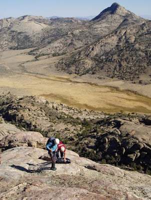
University of Wyoming researchers Davin Bagdonas and Carol Frost make observations on Lankin Dome, part of the Wyoming batholith, in central Wyoming's Granite Mountains.
Credit: Myron Allen
Geophysical monitoring of the ground above active supervolcanoes shows that it rises and falls as magma moves beneath the surface of Earth. Silica-rich magmas like those in the Yellowstone region and along the western margin of North and South America can erupt violently and explosively, throwing vast quantities of ash into the air, followed by slower flows of glassy, viscous magma.

But what do the subterranean magma chambers look like, and where does the magma originate? Those questions can't be answered directly at modern, active volcanoes.

Instead, a new National Science Foundation (NSF)-funded study by University of Wyoming researchers suggests that scientists can go back into the past to study the solidified magma chambers where erosion has removed the overlying rock, exposing granite underpinnings. The study and its findings are outlined in a paper published in the June issue of American Mineralogist, the journal of the Mineralogical Society of America.

"Every geology student is taught that the present is the key to the past," says Carol Frost, director of the NSF's Division of Earth Sciences, on leave from UW, where she is a professor in the Department of Geology and Geophysics. "In this study, we used the record from past to understand what is happening in modern magma chambers."

One such large granite body, the 2.62 billion-year-old Wyoming batholith, extends more than 125 miles across central Wyoming. UW master's degree student Davin Bagdonas traversed the Granite, Shirley and Laramie mountains to examine the body, finding remarkable uniformity, with similar biotite granite throughout.

"It was monotonous," says Bagdonas, who worked on the project with Frost. "Only minor variations were observed in granite near the roof and margins of the intrusion."

This homogeneity indicates that the crystallizing magma was generally well-mixed. However, more subtle isotopic variations across the batholith show that the magma formed by melting of multiple rock sources that rose through multiple conduits, and that homogenization was incomplete.

Studies of the products of supervolcanoes and their possible batholithic counterparts at depth are a vibrant, controversial area of research, says Brad Singer, professor in the Department of Geoscience at the University of Wisconsin-Madison. He says the research by Frost and her colleagues offers "a novel perspective gleaned from the ancient Wyoming batholith, suggesting that it is the frozen portion of a vast magma system that could have fed supervolcanoes like those which erupted in northern Chile-southern Bolivia during the last 10 million years.

"The possibility of such a connection, while intriguing, does raise questions. The high silica and potassium contents of the Wyoming granites differ from the bulk magma compositions erupted by these huge Andean supervolcanos. This might mean that the Wyoming batholith records the complete solidification of potentially explosive magma at depth, without the eruption of much high-silica rhyolite," Singer says. "Notwithstanding, this paper will certainly provoke a deeper look into how ancient Archean granites can be used to leverage understanding of the 'volcanic-plutonic connection' at supervolcanoes."

Large bodies composed solely of biotite granite are more common in the Neoarchean eon (2.8 billion-2.5 billion years ago) than in younger terrains. The reason may relate to higher radioactive heat production in the past, which provided the power to drive extensive granite formation, the UW researchers say.
***

Source:
The above post is reprinted from materials provided by University of Wyoming.

Reference:
Carol D. Frost, B. Ronald Frost, and James S. Beard. On silica-rich granitoids and their eruptive equivalents. American Mineralogist, June 2016 DOI: 10.2138/am-2016.5512